

Natural disasters like tornadoes and earthquakes can devastate communities and bring uncertainty in their aftermath when it comes to safely accessing buildings or homes. When an EF-3 tornado struck Jefferson City, Missouri, in May 2019, it killed three people and left over 600 buildings damaged, presenting first responders with an overwhelming response challenge. In tragic situations like this, facility owners and emergency planners play a key role in taking swift action to evaluate the damage done.
“Prior to the chaos of a disaster, it’s imperative that emergency planners and building owners understand the status of their communities’ facilities,” said Department of Homeland Security (DHS) Science and Technology Directorate (S&T) Program Manager Ron Langhelm. “Post-disaster, they need to have tools that can give them a clear picture of the damage, so they know how to address it.”
This year, during National Preparedness Month in September, S&T highlighted several technologies designed to help with disaster preparation, response, and recovery efforts. But the conversation shouldn’t end just because September did. We’re going to continue on sharing resources, some of which fit right in the palm of your hand.
 “This is a great opportunity to continue thinking about how your community is planning for the future and whether you have the necessary tools to respond,” said Langhelm. “Through joint investments, S&T has been able to deploy preparedness and response tools to many localities for front-line use. Our hope, along with that of our partners, is that communities use and help us improve these tools.”
For instance, Langhelm has led S&T’s efforts to work with the Central United States Earthquake Consortium (CUSEC) to enhance two GIS-based apps used for pre- and post-disaster assessment: the Rapid Visual Screening (RVS) and Building Safety Assessment (BSA) apps. These tools adapted paper processes into a mobile format to deliver data quickly and easily to a wide array of stakeholders who need access in advance or in the wake of a disaster. CUSEC developed early iterations of the BSA and RVS apps with funding from FEMA’s National Earthquake Hazards Reduction Program (NEHRP) and the Delta Regional Authority. Through S&T’s support, CUSEC was able to significantly enhance the apps and make them deployable on a national scale. Both of the apps are free and available for use via the S&T-supported Regional Information Sharing Platform.
Assessing Vulnerable Facilities Before a Disaster
Part of S&T’s partnership with CUSEC is to better equip the Central U.S. with decision-support technology that can be applied to earthquakes and other hazards, and the RVS app directly supports these efforts. This region has a 25 percent to 40 percent probability that a magnitude 6.0 or greater earthquake could occur within any 50-year time period, making preparation paramount.
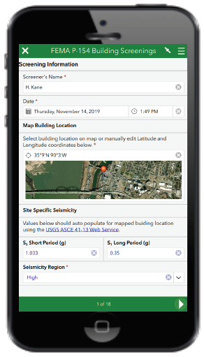
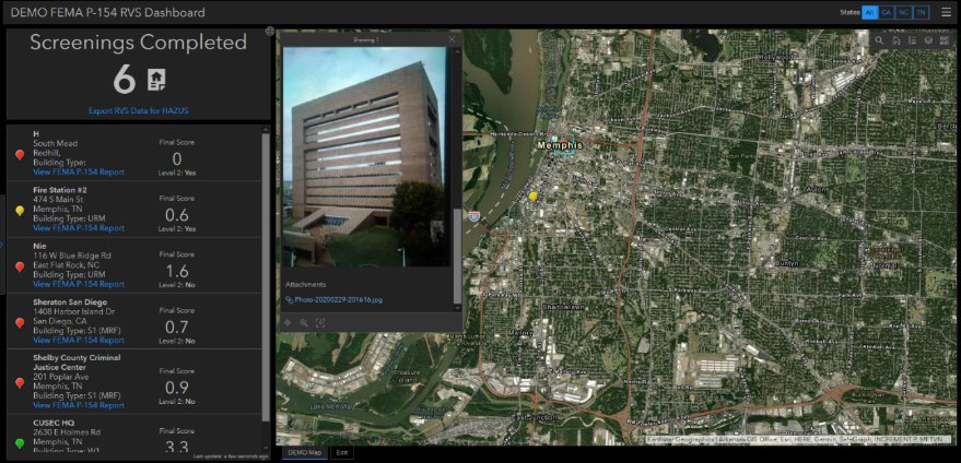
The RVS app helps screen buildings vulnerable to direct earthquake-induced damage prior to an event. Its data collection, visualization and reporting capabilities are adapted from FEMA’s P-154 Rapid Visual Screening of Buildings for Potential Seismic Hazards (3rd ed.) (PDF, 388 pgs., 50 KB) methodology. FEMA’s P-154 was first published in 1988 and has seen several updates that incorporate the evolving knowledge concerning seismic hazards and building structures, as well as new field data collection and reporting technologies.
“Together, FEMA, S&T and CUSEC have been able to modernize an existing methodology to improve mitigation efforts,” said Langhelm. “By using the RVS app, building owners and emergency planners streamline the FEMA P-154 paper process, and can create a database of potentially vulnerable structures.”
The RVS app uses commercially-available technologies from the Environmental Systems Research Institute (Esri). Information in the database can be viewed and edited using a built-in operations dashboard or can be displayed in a FEMA P-154 standard report format using the RVS app reporting tool. Data collected using the RVS app can also be exported to a spreadsheet or to FEMA’s HAZUS loss estimation software.
Following a local assessment of buildings or facilities, the results can be used to identify and prioritize opportunities for mitigation efforts. Communities have already begun putting it into use. For example, the Northeast States Emergency Consortium used the app to screen critical facilities in Maine for potential vulnerabilities, and in 2021, Kentucky and Tennessee also will use the app to screen critical facilities. The Missouri Seismic Safety Commission has begun using the RVS app to conduct rapid visual screenings of schools as part of their initiative to improve earthquake safety.
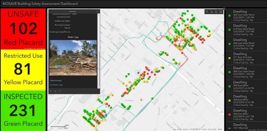
BSA App Used After 2019 Missouri Tornadoes
The days following a disaster can be devastating for communities and can have lasting impacts on its economy and well-being. After the tornado in Jefferson City, the Missouri State Emergency Management Agency authorized the Missouri Structural Assessment and Visual Evaluation (MOSAVE) Coalition to assess homes in the affected area for safe occupancy.
The BSA app, developed in 2018, was deployed for use. Designed to speed data collection, the MOSAVE assessment teams, comprised of architects, engineers, and building construction professionals, used the app to conduct structural assessments to document the conditions observed within the affected area.
“This was the best data collection method I’ve used in all my deployments,” said Michael Ash, MOSAVE member.
MOSAVE structural inspectors entered information as they assessed the buildings and structures in the field. That information was then used to update a dashboard at the emergency operations center, giving local authorities a clear picture of the tornado damage in a prompt and efficient way.
MOSAVE Chairman Ben Ross stated, “During the Cole County deployment, the app saved a lot of time updating leadership on our progress since people were able to look at the live dashboard for updates.”
Like RVS, BSA was also developed with Esri technologies and includes data entry forms for field assessment teams and dashboards that provide real-time assessment results and situational awareness to emergency managers. For the Jefferson City tornado deployment, the app helped identify building safety issues, such as leaning structures, damage to building supports, or buildings off their foundation. According to MOSAVE team members, this was a significant time savings over the standard paper process. Following the May 2019 tornado, MOSAVE provided feedback that validated the efficiency of using the BSA app to conduct safety assessments.
Not long after this tornado, the tool was further validated at FEMA’s 2019 Shaken Fury exercise where it was one of several technology solutions demonstrated to enhance information sharing and situational awareness capabilities. Volunteers from the Tennessee Structural Assessment and Visual Evaluation Coalition simulated data collection and reporting to the Tennessee Emergency Operations Center, providing 51 reports during the exercise that tested the field app and populated a dashboard of results.
Taking the apps for a test drive
To try out the apps, bring them into your own ArcGIS organization, or just learn more about additional use cases, please visit CUSEC’s RVS app and CUSEC’s BSA app pages on the CUSEC Regional Information Sharing Platform.