

Last year at this time, Hurricane Ian struck Florida’s Gulf Coast as a category 4, with additional landfalls in Cuba and South Carolina. By the time the powerful storm retreated, Ian was responsible for over 150 deaths and more than $112 billion in damage (PDF, 72 pgs., 6.9 MB). When hurricanes make landfall, coastal communities are especially vulnerable to storm surges, high winds, and freshwater flooding. Residents can be left without clean water, food, shelter, electricity, and access to medical care for days. Communities need proper tools to adequately prepare for these storms, especially as climate change worsens the impact of these extreme weather events.
The Coastal Resilience Center (CRC), a Department of Homeland Security (DHS) Center of Excellence funded by the Science & Technology Directorate (S&T), is working to arm communities with modeling and evaluation tools that will give local leaders a leg up in boosting response and resiliency. This year during hurricane season, CRC—led by the University of North Carolina at Chapel Hill (UNC-CH) in partnership with Jackson State University, a Historically Black College and University—is using its high-performance ADvanced CIRCulation model (ADCIRC) to forecast storm surges, tides, and coastal circulation. During Hurricane Ian, and more recently during Hurricane Idalia in August, ADCIRC provided detailed prediction of storm category, landfall location, radius, windspeed, surge levels, and storm track. This information was incorporated into daily operations briefings for DHS leadership and informed local communities across the East Coast.
However, being able to predict certain variables of a storm with tools like ADCIRC may not be enough. Cities, towns, and counties are required to adopt and update standalone emergency management plans for a variety of threats, including coastal hazards, floods, and wildfires, but there is often little coordination between regional planning efforts, which may lead to inefficiencies, duplication of effort, or even result in conflict between plans. Better integration of plans at the city, county, state, and federal levels could lead to better use of common resources, less investment in high-risk infrastructure and development, and ultimately protect lives and property.
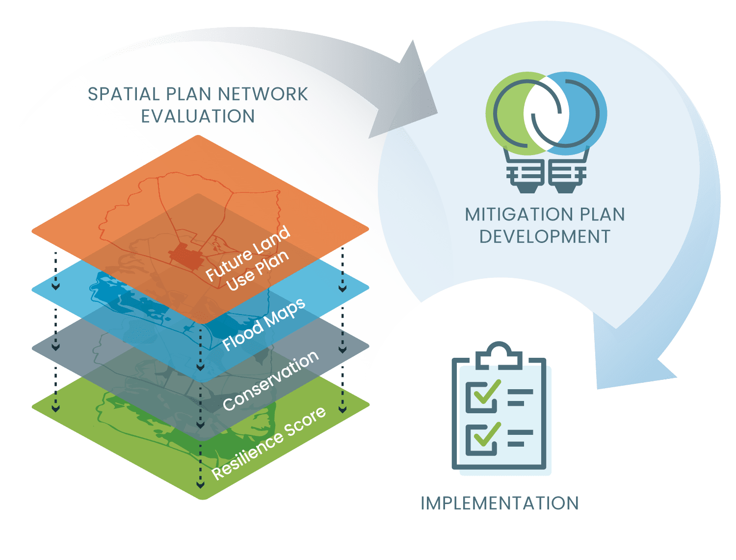
To improve planning and coordination efforts across geographic regions, CRC launched the Plan Integration for Resilience Scorecard (PIRS™) website, a new resource that helps local government officials evaluate an area and sort out networks of plans to reduce hazard vulnerability and protect the economic, social, and environmental well-being of their communities. Developed by CRC with funding from S&T, the website offers a free guidebook that helps communities navigate the process of assessing and aligning their plans to maximize investments and reduce potential disaster impacts.
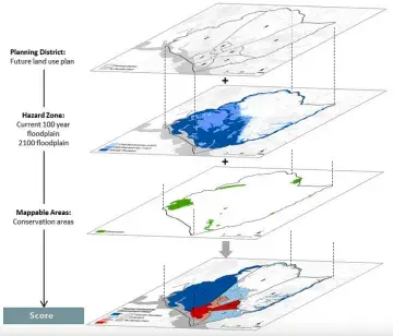
“PIRS™ helps communities evaluate and coordinate their networks of plans using a unique method of ‘spatial plan evaluation’ that looks explicitly at the spatial language in policies and their likely effects on hazard vulnerability,” said Dr. Siyu Yu of Texas A&M University, who co-leads the project with UNC-CH’s Dr. Phil Berke. The PIRS™ guidebook, which has been implemented in at least 10 U.S. communities to date, also identifies potential response shortfalls by layering multiple plans.
The PIRS™ website is the culmination of years of work by the CRC research team, which has created a scorecard system for planners to ensure one plan doesn’t impede, prevent, or undo the work of another. PIRS™ is an approach that gathers numerous emergency plans and policies, as well as information on hazard zones and planning districts, then analyzes how these elements interact, down to the impacts on individual neighborhoods.
“Hazard mitigation planning tools are imperative as they can be used over time to help reduce risks and future losses,” said Rebecca Medina, director of S&T’s Office of University Programs.
PIRS™ provides invaluable insights about planning priorities, promoting better collaboration, and determining which parts of a community are especially vulnerable to disasters. The scorecard can provide the motivation and information that local government officials and decision-makers need to better integrate their networks of plans. In addition, end users, including those from FEMA and individual communities, will find case studies, publications, and webinars to guide them in emergency planning and plan integration, as well as provide them with access to a PIRS™ course through the American Planning Association (APA).
Through key partnerships with APA and the National Institute of Standards and Technology, PIRS™ has made a widespread impact beyond its original application to flooding. New applications focused on multi-hazard scenarios, including wildfires and urban heat, are demonstrating that the tool’s approach to plan integration can be more broadly adopted.
“We need to be preparing to adapt to the changes that are coming,” said Dr. Berke. “We will face drought, wildfire, mass migrations, and conflict. PIRS™ is one tool to help communities move in the direction of resilience.”
Using the right tools when preparing for natural disasters can lead to better coordination amongst coastal communities and may reduce a storm’s overall impact—lessening recovery time and creating safer communities. “An effective planning tool like the PIRS™ Scorecard helps emergency managers develop and deconflict response plans, paving the way for communities to recover quickly and ideally thrive in the aftermath of a natural disaster,” says Medina.