

Over the past several years, severe storm surges, flooding, and other life-threatening phenomena have affected coastal communities in myriad ways. When weather systems threaten the coast, emergency responders rely on high-precision storm modeling systems and real-time data to accurately predict hurricane activity and flooding threats, collaborate with each other, and make critical decisions that will protect the lives and property of millions of U.S. residents.
During the 2018 hurricane season, as Hurricanes Florence and Michael blew toward the Carolinas and the Florida panhandle, respectively, the United States Coast Guard (USCG) and the Federal Emergency Management Agency (FEMA) were using a suite of early warning technologies and storm modeling software to inform their operations and responses both before and after the hurricanes made landfall. This suite of tools, better known as the ADCIRC Prediction System (APS), played an integral role in accurately predicting the storm surges, flooding, wind and wave interactions, and speed of tides and currents associated with both Florence and Michael.
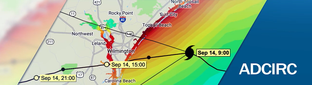
APS uses modeling technology with a 30-year track record of providing accurate representations of coastal water movement, flooding, and storm impacts. The system, developed and operated by the Coastal Resilience Center, a Department of Homeland Security Center of Excellence led by the University of North Carolina at Chapel Hill in partnership with Jackson State University in Mississippi, and funded by the DHS Science and Technology Directorate (S&T).
APS consists of three components: Advanced CIRCulation (ADCIRC) Storm Surge Model , a high-resolution, high-precision storm surge/coastal flood model; the ADCIRC Surge Guidance System, a software infrastructure that automates ADCIRC for operational deployments; and the Coastal Emergency Risks Assessment web portal, which makes model output readily available to end users.
“The ADCIRC Prediction System provides some of the most detailed and accurate storm surge and flooding information that is publicly available for the east and gulf coasts,” said Dr. Rick Luettich, the leader of the APS development and operations team and the lead Principal Investigator at the DHS Coastal Resilience Center of Excellence. “APS provides important information assisting individuals who are tasked with making important decisions regarding evacuations, infrastructure assessment, and disaster recovery and mitigation planning, both before and after a storm has reached shore.”
APS data has been used by both federal responders (e.g., USCG, FEMA, the National Oceanic and Atmospheric Administration, the U.S. Army Corps of Engineers), state emergency management offices and local community leaders to get ahead of storms and protect lives and property. This is especially true of the past nine years. During more recent storms such as Hurricanes Irma, Maria, Matthew, Gustav, and Ike, emergency response organizations planned and implemented evacuations, the placement of recovery resources, search and rescue operations, and damage assessments based on information from APS. Many of these federal organizations also rely on APS during the rest of the year to provide data for applications such as FEMA’s National Flood Insurance Program, identification of flood zones, the design of levees and other protection measures, and predictions of how flooding may impact vulnerable regions in the future.
“When severe storms approach, the Coastal Resilience Center team works non-stop getting ADCIRC Prediction System information to those who need it to make crucial decisions,” said DHS S&T Program Manager Eleanore Hajian. “As hurricanes approach the East and Gulf Coasts, their work helps save lives.”
While APS has proven itself to be a crucial and versatile tool for real-time coastal flooding predictions, Luettich is already looking to the future to see how it can be improved.
“APS is a community-driven system with a wide-range of potential applications,” Luettich explained. “Since its results are accessible to organizations ranging from multiple levels of government to academia to everyday citizens, we want to continue making it more accurate and useful to those who rely on it. Thanks to continued support and funding from DHS S&T, we are continuing to develop the APS capabilities, such as enhanced wind models, improved land surface representations, and better inclusion of precipitation-based flooding in the coastal zone.”